The formation and development of the Yellow River
As
the Chinese nation's mother river, the Yellow River at what s formed?
In order to find out the birth of the Yellow River s, geologists and
archaeologists use many kinds of advanced methods, many years of hard
work, and finally draw the latest research results: the development of
the Yellow River in 1.5 million years ago, by the crustal movement and
erosion, handling, stacking and work together, in the long history of s
gradually formed.
"Vicissitudes in the" is a dramatic change in the
parable, original intention is to say the vast sea into the field of
farming. The Yellow River from the ancient times go today, though not
things change, but is also experienced a long process of development.
About 1.5 million years ago, in the geologic called tertiary and
quaternary early pleistocene s, at that time, in what is now the Yellow
River basin, there are many ancient lake basin. About dating back 1.5
million to 1.1 million years, between the previous those ancient lake
basin of the west, there was the ancient just, ancient eling and if and
cover lake; Today's bohai sea, at that time is also a inland lake basin.
The lake basin is a home to return to the local river, lake basin
between each other is not connected, just form independent interior
drainage, but their formation and development, has been pregnant with
the great Yellow River.
It between 1.15 million and 100000, the
Yellow River happened intense crustal movement, lake basin uplifted zone
between the obvious rise, river sharply incised. Strong geological
activities not only make early paleochannel deepen widened, and at the
same time, water itself huge headward erosion effect, make early some
intermittent river gradually through. Dating back 500000 to 100000
years, the Yellow River basin in addition to the individual ancient lake
basin also exist alone outside, others due to the formation of the
ancient Yellow River hydrologic network, the river are in the river, the
Yellow River basic run-through, the Yellow River channel also basically
finalized the design. Can say, the Yellow River conceived in about 1.5
million years ago, dating back 500000 to 100000 years begun to take
shape.
"Yellow River water heaven, running to the sea no longer
return". Ancient don't know the source of the Yellow River, also do not
know the Yellow River development history origin, think this is huge
river dominated the fate of mankind from heaven, pentium eastward until
the day at the end of the sea. They think it all so since ancient times.
In fact, the history of the Yellow River running into the sea is also
true of.
Dating back 100000 to 10000 years, in the Yellow River basin
of the most ancient lake basin have die, and gradually evolved into the
up and down through the Yellow River. At the same time the ancient
HuangHaiXi invasion, in today's east of tianjin formed the ancient bohai
sea, from then on, the Yellow River lake from tianjin into the bohai
sea. In this geological process, the Yellow River of water erosion force
constantly to bed work, in the geological effect of the increase of
river, the water erosion force make bed constantly brush deep, and
subsidence of the reach and constantly fill up, day after day O in about
10000 years ago, the bohai sea and two west influx has near the canal,
sea level rise, make the Yellow River water can't continue to smoothly
east into the sea, and on the mainland flood wreak havoc, this was later
"dayu water conservancy" and YuWang communist-held.
The changes of the downstream channel
As
history steps without a moment of suspension, the Yellow River is also
in constant motion in the development. Enter has book can take an
examination of s, the Yellow River is still in the constantly changing,
the saying goes "thirty years hedong hexi, 30 years", although some
exaggeration, but vividly portrayed the Yellow River channel and
frequent changes of the scene. The change of the Yellow River in the
upper, middle and lower reaches are happened, but, the evolution of the
middle reaches of the Yellow River to the whole development of the
influence is not very big. The Yellow River channel significant and
frequent changes, mainly in the downstream.
Since water less than
sand, a large number of sediment deposition in the downstream, in the
long run, channel is foul, the river can smooth the release, have to
"path". History of the Yellow River breach redirection records a lot,
but experts put the Yellow River channel of major change into five
times.
According to the historical documents research, from 602 BC to
the territory of the republic of China period, the Yellow River roughly
along the north, middle and south three direction route, alternating
into the sea. North road, north from the horse buccal river to tianjin
into the sea, to roughly 670 years. South road, which is, namely, in the
south of huaihe river from the sea, roughly 720 years; The middle,
namely the current along the river in shandong LiJin near the sea. Total
lasted 1211 years.
The Yellow River in the great plains change, a
large number of sediment deposition, all the past of the Yellow River
during menses, have all become a above ground level of sand strip,
today, we still can see 3 types: the old migration have left traces.
(a) YuHe
It
is said that in ancient times, the Yellow River there is a major flood,
flood in the world. Later dayu water conservancy, using the method of
counseling, the flood is divided into "JiuHe", guide into the bohai sea,
calm floods. In our country, "nine" is the very word, and not
necessarily is said to have nine river. The earliest record of the
Yellow River geography book is the minister · yugong "and" hill sea
classics ", these two books in ancient times the description of the
Yellow River and today's archaeological discovery generally consistent
with that in the xia, shang and zhou period, the Yellow River downstream
channel in natural state, low-lying place distribution many lakes,
rivers in collusion with the lakes, is divided into several branch, in
the plain on the loose wander, and come to the bohai sea.
The
minister ", it is a Chinese ancient history documents and part lies the
ancient deeds assembly sex work, "yu gong" is one of the article, the
author is unknown. Now people think, it is the works of the warring
states period. It USES natural zoning methods about the geographical
conditions, the country is divided into "kyushu", under the mask of for
dayu after water conservancy administrative division system. It divides
the Yellow River basin of the mountains, rivers, 籔 ze, soil, the
product, the geld and traffic, the comparatively detailed records. Later
generations "yugong" described in the Yellow River, known as the "YuHe"
or "YuWang communist-held".
According to the ancient records and
geological condition analysis, 3 types: the old in the downstream
sheetflood period, along the way accepted by the size of the outflow of
taihang mountain streams, and it out today after the branches, the now
repair wu, the fine, xinxiang and WeiHui, QiXian, ShangYin and anyang,
handan, xingtai, east side, through the DaLiuZe, scattered into the
bohai sea.
(2) the warring states to the western han dynasty period of channel
Research
of the Yellow River, the "YuHe" as a material record since the original
channel, while the first a major channel change took place in 602 BC,
is ZhouDing WangWuNian.
In 770 BC, the capital ZhouPingWang moved to
the east in luoyang, China's economic center from the Yellow River
middle reaches to the downstream direction transfer. Along with the
economic development imbalance, zhou dynasty each vassal state of the
balance of power has also changed, in hundreds of years, "spring and
autumn five bully," "warring states seven male 'have appeared in the
history stage, their excellences. At this time, people have realized
that the Yellow River is a beneficial and harmful the river. They're
banking flood control at the same time, to develop, is the river silt
diffuse beach. Levee engineering construction makes the Yellow River
changed from time unrecorded sheetflood condition, in the embankment
constraints in the plains, loose the river gradually becomes one.
Levee
constraints, so that the river fan, but sediment deposition in the
downstream of the river, the river bed up continuously. ZhouDing
WangWuNian, the Yellow River mouth Xu sincerely in accommodation of
cell, the mainstream YuWang communist-held by northeast, by now the
puyang, name, GuanXian, linqing, plain, cangzhou, etc in the pair of
huang into the bohai sea. This article channel keep to the western han
dynasty period, after more than 600 years, known as the western han
dynasty.
During the western han period, along with the economic
development, population increase, people began to DiNa again in
repairing embankment, and in the beach in farming, build the house, the
warring states period is more complex than the channel, more twists and
turns danger and more significant the ground river, have increased the
possibility of breach of the Yellow River. In 132 BC, the Yellow River
in puyang HuZi breach, run water into southeast juye ze, flood into the
huai. Flood flow after more than 20 years, entrance to plugging complex.
After small runoff overflow continuously, the 11th year, the Yellow
River in WeiJun breach, the floods in the lu ji between flood nearly 60
years, causing the Yellow River's second big redirection.
(3) the eastern han to sui and tang dynasties, the Yellow River
The
eastern han river keep for nearly one thousand years, meantime WangJing
river regulation to keep stable flow played an important role. In 69,
han Ming emperor sends WangJing river regulation, river diversion, and
be proud of Yang to thousand by (now shandong step county northeast)
banking li, and adopted a series of supporting channel management
measures, stable flow, xinhe smoothly into the sea.
This period,
HuangHeJing today puyang, he finds and gaotang, plain, in LiJin area
into the sea, river is called during the eastern han dynasty. This
article river, after the wei, jin and southern and northern dynasties
has been extended to the northern song dynasty era, tang and early song
dynasty, the Yellow River and in puyang, between huaxian county enjoys
runoff overflow frequently.
(4) the Yellow River
The northern song
dynasty, is the Yellow River becomes more and more serious disasters,
channel change very severe an era. The ancients said, "HuangHeQing,
saint out", visible, people is the Yellow River's calm and political
clear and bright relates in together. The northern song dynasty period,
the kaifeng, the Yellow River downstream become the political, economic
and cultural center. The Yellow River and the interest of the ruler is
closely related to the management of the song dynasty is very important
to the Yellow River, the court ministers ouyang xiu, WenYanBo, su zhe,
etc are put forward a claim on river management. There was a deep river
regulation to explore, develop the work consisting of the dyke projects
such as construction technology, also started the practice of desilting
content of the comprehensive utilization of Yellow River water sand up
to a new stage. But this period, due to the channel siltation, and the
river had obvious increase; More due to the northern minorities
increasingly powerful, north liao invasion become the northern song
dynasty's serious trouble or danger, the strategy of the Yellow River
management is often influenced the influence of military, increased the
can to the Yellow River for natural moat, curb south make the enemy of
the content.
In the song dynasty, the Yellow River has remained when
the eastern han dynasty flow, later channel YuGao and dangerous cluster.
In 1048, the Yellow River in puyang quotient hu consisting of the
breach, diversion north flow, and took away yongji ditch from tianjin
into the sea, this is the history of the Yellow River third big change.
After
more than 10 years, the Yellow River and it has happened so many times
of overflow, toward that the governance is not consistent, and political
existence "Lord and pie" and "war party", in river regulation, also
appeared two pie opinion. A party claim back to hedong flow, a party
that let the Yellow River diversion north flow. At that time, the river
has been in the above two propositions to the influence of the pendulum
to the bottom.
(5) dollar to the Ming and qing dynasties of the Yellow River
In
1128, JinBing south, the southern song dynasty in the frontier. In
November, Tokyo (today kaifeng) left-behind DuChong in Yellow River
south bank brook county (now weihui municipal) and between huaxian
county enjoys (about the redirection site, there are other statements)
baring embankment against the enemy. But, with water and the method of
soldiers often is stupid and invalid, rushed out of the flood embankment
did not stop JinBing south into the pace, on the contrary make
HuangHeNa universal approval from the yellow sea, cause and a large
diversion.
In Yellow River took the standard 700 years, huaiying
above, channel swing frequent, huaiyin the following deposition serious,
estuary extended rapidly. Since the Ming dynasty yongle its capital
Beijing later, harbor development, management to keep the Yellow River
harbor as the main purpose, built in the Ming dynasty when the
embankment once weight exceeds that of south, 15 century of the Yellow
River in zhengzhou in the following four points south road into
requirement; In 1495, to prevent yellow hebei make sliding shipment, and
in the north of the Yellow River and repaired do dyke, from then on,
the regime more tend to south.
1546 years later, kaifeng to DangShan
built between southern embankment, the river had fixed channel,
HuangHeJing today LanKao, shangqiu, DangShan, xuzhou, suqian, huaiyin,
ripple water into the yellow sea. The first-class road has been extended
to the late qing dynasty, the Ming and qing dynasties during this says.
(6) the current channel
In
June 1855, the Yellow River in the copper tile compartments (now LanKao
DongBa head) breach, the mainstream to flow to the northwest and bends
to the northeast, burst cho chang canal, directly endanger the rulers
interests. The qing government in breach the beginning of quasi start
construction closure, but at that time the taiping heavenly kingdom and
twist army of the peasant movement is in the ascendant, the qing
government do our utmost to suppress, really too busy to also cannot
take care of river runoff, XianFengHuangDi letter respite plugging
close, from now on the Yellow River take high qinghe by shandong LiJin
into the bohai sea, this is by far the last large diversion.
The
Yellow River breach, because of copper tile compartments below the
wuding river channel. To the early pathogenesis, the qing government to
QuanYu states county self-financing, in xinhe cross-strait along the
river, build up the people Nian to prevent flooded diffuse. Around 1885,
built by the government to set up new river embankment in succession.
After
the formation of the new river, copper tile compartments below channel
traceability scour, bed degrading, the henan province rarely appears
runoff overflow. 1933 a big flood, henan runoff overflow as many as 50
place. Since then, the henan Yellow River runoff overflow increase
gradually.
In 1938, the national government in order to prevent the
Japanese west, in zhengzhou HuaYuanKou opens the Yellow River
embankment, the whole river beheaded diverted from shahe, YingHe into
the huai river, Yellow River in henan, and anhui, Sue flood for as long
as nine years. On June 15, 1947, HuaYuanKou entrance plugging complex,
the Yellow River during return.
From copper tile compartments breach
so far more than 140 years, in addition to 1938 human steak mouth
redirection nine years outside, the Yellow River has been the puyang, he
finds to cho chang through the canal into big qinghe, in LiJin into the
sea. Copper tile compartments diversion, because hydraulic traceability
scour, copper tile compartments above cross-strait into a high beach
and form the relatively favorable bed. Since 1947 HuangHeGui so far,
already AnLiu 50 years, because of sediment deposition, bed drive up, in
the downstream and aggravate the ground hanging river situation. But if
history for five thousand six hundred years or years of channel phase
comparison, the current channel is still a young channel.
The Yellow River downstream channel change situation see below.

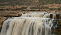
Serious natural disasters
Historically,
the Yellow River is a calamitous river, sand, sand river, the good
silting, ShanXi, good definitely. Especially the downstream, flood
runoff overflow very frequent, "three years two breach, one hundred a
diversion" is the posterity of the Yellow River flood disasters image
description; At the same time, the Yellow River often suffer from HanBa
wreak havoc. The Yellow River flood disaster, to have brought people of
river basin in suffering.
Raging flood
A deep, floods
Heavy
rains and flooding of the Yellow River, occurs in every July to October,
known as the "FuQiu DaXun". Ice slush floods, occurs in two in March,
called "ice run". FuQiu DaXun and ice run breach, can cause serious
disaster.
According to the historical data statistics, from 602 BC to
1938 2540, the Yellow River downstream breach flood years have 543,
diversion and times, the major migration 5 times. The Yellow River
breach flood range, north to tianjin, south of jianghuai, channel in the
huang-huai-hai great plains between multiple swing.
The Yellow River
sediment concentration at the world of rivers. As early as in sweat
generation, there is "a stone water and six bucket mud" said. Since
water less than sand, a large number of sediment deposition continuously
in the downstream channel, accumulate over a long period, form bed
obviously higher than the ground "hanging river", hanging difference as
high as several meters to ten meters. Pentium river only on two levee
bound, floods once broken levee breach, like collapse dam flow, high
speed pouring, the potential like be strategically situated, bold and
flowing, the destroy effect, far more than general plain rivers.
The
Yellow River flood can give the urban and rural cause devastating
disaster. Every time the Yellow River diversion, will be washed out the
local rural cottage, often have the whole town and even the whole city
lost horror. The Yellow River seven dynasties kaifeng, history has 6
times by the Yellow River water flooded, every time flooded, to kaifeng
people's devastating disaster. According to archaeological excavations
confirmed, today we see the kaifeng, gates in the city: the song dynasty
kaifeng city base in today's ground the following 8 meters, the Ming
dynasty weeks wangfu hall in today's ground below 4.6 meters; Xuzhou
city of the Yellow River near the communist-held also unearthed ancient
xuzhou city sites.
Due to the characteristics of the Yellow River
sandy, flood runoff overflow water back after sand deposit, a large
number of houses, fertile land, graff, roads, Wells are sediment buried,
land desertification, to ecological environment caused by the impact,
years difficult to restore. In 1938, the Yellow River in HuaYuanKou by
artificial steak port redirection, formed HuangFanOu, until now, to
ecological environment caused by the bad impact is not entirely
eliminated. Every time the flood runoff overflow caused casualties and
economic loss is huge, the political stability and the ecological
environment, such as damage, it is difficult to use digital to
calculate.
The earliest in China about flood legend, occurred in the
21st century era of many legends, people are fleeing their homes were
destroyed by the flood. After Gun nine years, yu 13 years of management,
the flood subsided. The spring and autumn period and the warring states
period, also have large "continuous heavy rain" records. After the
western han dynasty, about flood describes many more. As the state's
serious trouble or danger, the more to modern times, historical records
of the Yellow River flood and disaster in the more detailed records. The
Yellow River flooding can be described as "ShiBuJueShu".
The qing
dynasty to the republic of years, in the middle and lower reaches of the
Yellow River flooding happens mainly has the following several times:
Twenty-six
years qing qianlong (1761), from the lunar July 15 to 19, the Yellow
River tributary Iraq, rockwell, the Yellow River river dawen and
tongguan to main branches interval, fierce drop rain, heavy rains center
in henan XinAnXian, Iraq, luohe runoff overflow. According to the
analysis calculation, HuaYuanKou peak discharge for 32000 cubic meters
per second, the flood to the downstream, the WuZhi, Xing ze, YangWu, fu,
culture, etc DiDuan north and south sides of overflow occur, ZhongMou
YangQiao breach of the entrance of "hundreds of zhangs", the river
JiaLuHe until it gleamed. In this the deluge, Yellow River downstream
breach and place, yi clamp beach area depth "above the", luoyang, gong
in the county are was flooded, QinYang, repair wu, wu prevent and
fraternity, the irrigation city, depth "five or six feet" and even "the
depth of more than". Henan, shandong, anhui province dozens of state,
county flooded.
Clear light twenty-three years (1843) in July, the
Yellow River flooding happen again, according to the official report at
the time of the ShanXian WanJinTan water regime, the floods rise
rapidly, in front of the flood has not dropped, the subsequent floods
come, wave remove mountains, a day of ten hour between, swelling "two
zhangs eight inches", such as the rise in history books recorded there
has never been. In ShanXian area flood caused great disaster, has also
been local "light 23, the Yellow River up to heaven, and wash away
TaiYangDu, take away WanJinTan" folk. The size of this year's June, the
Yellow River downstream ZhongMou this already breach, in the flood, the
entrance ZhongMou are washed to the more big, up to "more than three
hundred zhangs," big water two strands of straight to the southeast,
henan ZhongMou, WeiShi, fu, general xu, Chen leave, huaiyang, FuGou,
Sherwood, TaiKang, QiXian, LuYi, anhui province, fuyang, tai ying
superbly generally suffer from flood disaster. The posterity according
to flood trace analysis calculation, ShanXian when peak discharge for
36000 cubic meters per second, is the historical investigation maximum
flood.
August 10, 1933, the Yellow River ShanXian
station appeared since 1919 since the site maximum flood, maximum peak
flow of 22000 cubic meters per second, henan county, WuZhi, changyuan,
blue seal, take an examination of city, the north and south there are
more than 50 place breach, fresh, juye, dingtao, submerged plant. Xuzhou
city is the Yellow River dike, be burst "in more than ten". Stream a
stock index north, puyang, he finds, and zhang, si 5 four county do into
ZeGuo; A stream of guidelines, intrusion anhui. The waters flooded and
the henan, shandong, hebei, jiangsu province of 4 30 counties, the
affected area of 6592 square kilometers, affected 2.73 million people
killed 12700 people, estimate the flood loss reduced silver dollar 270
million yuan.
Second, flood and "water generation soldier"
The
Yellow River runoff overflow, due to the natural and economic reasons,
plugging complex very difficult, sometimes the river breach, 10 years,
20 years entrance can't block complex, yellow water crosscurrent,
ravaged a precise definition. Of course, there are also some breach
intentionally don't block a strange thing. WangMang kingdom was three
years (the 11 years), the Yellow River in the north of puyang today
WeiJun boundary breach. WangMang think the Yellow River diversion east
flow, his family's ancestral grave will no longer be in distress, to the
peoples, no plugging complex, as the river free flood.
In the
history of the Yellow River runoff overflow, have a plenty of for
military purposes, man-made destruction caused by the embankment.
The
spring and autumn period and the warring states period, the lower
Yellow River dikes built is very common, due to the seigneur division,
each does things in his own way, the dike often to adjacent to the
whole, every state attack each other between cutting, often with water
generation soldiers, human never river phenomenon happens continuously:
in 359 BC, chu cutting wei, never river irrigation changyuan; In 332 BC,
neat, wei joint cutting zhao, zhao river runoff water, neat, wei
coalition in the rolling flood forced retreat; In 281 BC, zhao wei in
cutting in runoff river again. Never river in tapping felling is played a
certain role, but to the people brought huge disaster and pain.
This
period, the most famous "water generation soldier" happened in 225 BC,
the qin shi huang unified China prepared, in which the divide and
conquer strategic perished South Korea, ZhaoGuoHe after yan, and focused
on wei. See neighbors have been breached, and he has become so
frightened. Qin qin only sent the son of general WangBen, led the 100000
army siege wei capital girder, and lead the Yellow River water of gap
filling city. In the flood and under the threat of force, only 3 months,
wei was perished. The gap WeiHuiWang excavation, in order to improve
the traffic condition, the development of economy, FuGuoJiangBing and
dominate the central plains, he would never think of in after more than
years, from the gap draws will help a tyrant to do evil, injure both
hurt his sons. Sima qian in shi-ji eloquent appraisals appended to qin
dynasty recorded by the event.
Qin never river irrigation girder out
wei, the warring states period to the water generation soldiers to the
highest level, and the southern song dynasty DuChong never river is
affected the change of the Yellow River. In 1128, the southern song
dynasty ZhaoGou regime in order to prevent JinBing south into, Tokyo
left-behind DuChong never open Yellow River, water and soldiers. As a
result, the artificial river runoff did not stop JinBing of fighters,
they cause great disasters, history of the Yellow River on long-term
south flood into the beginning of approval.
In the northern song
dynasty, HuangHeCeng once considered natural military barriers, hope to
take advantage of the Yellow River this "natural moat" in military play a
role. When qidan in the "east flow" north of the equator, and north
flow has also is in the qidan within the territory. Due to the central
plains of qidan nationality has long advocated east flow such as
minister WenYanBo people think, and the river flows east central plains
not losing liao army against the natural barrier, right company doing Di
king more clearly point out that cangzhou is to contain the liao army
fortress, and the river flows east not, on the south bank of the river
in cangzhou, liao army from cangzhou can reaching to the capital, which
is no barrier. And su zhe, argues that, now of the Yellow River has had
very different, the river in limiting the liao army is famous and no
real. Because, shallow water, take clothes can across the river, Depth
of water, take a boat can also through; Winter the ice, but also such as
royal road, want to take the water as natural moat to block the liao
army fighters is impossible.
The two sides tit for tat, and are
government ministers, the emperor also didn't the mainstay. Since 1088, a
moment is daxing engineering back to the river for a while, then a
letter shutdown. Finally back to river opinion prevailed, east flow
diversion engineering characteristic in succession, four years later,
the river has most of the east flow. But, HuangHeDong flow but 5 years,
again breach. The river north out of a new flow, still in the past
"north flow" of the NingJun dry near the sea, the east flow stop. The
Yellow River finally didn't like to be ruler in role against the enemy.
In
1642, the leadership of the help peasant rebel army besieged kaifeng.
In order to solve the siege of seal, GuanJun is in today kaifeng black
duty should open the mouth of the Yellow River levee, water flooded
insurgent and insurgent and in the upstream of the 30 go horse of river
rushed GuanJun irrigation. Results two strands of water into the city,
drowning residents hundreds of thousands of people, causing the city
kaifeng flooded history tragedy.
In the summer of 1938, Chiang
kai-shek government in order to prevent the Japanese west, push aside
zhengzhou Yellow River HuaYuanKou levee, water generation soldiers,
caused the extremely cruel of extreme flood, in Yellow River, huai river
is formed between the HuangFanOu.
1937 "on incident", Japan launched
a full-scale war of aggression launched, 1938 to may, our country
Peiping, Tientsin two cities and hebei, shanxi, shandong province, such
as most of the area has been the invading Japanese occupation, taiyuan,
Shanghai and nanjing and other cities also have fall. May 19, in xuzhou.
The Japanese have controlled the beijing-shanghai railway and the
longhai railway, the assemble a large number of troops along the longhai
railway west make. Kaifeng tight, the critical.
In order to delay
the Japanese west, the KMT first war zone chief executive department
side to blow up the Yellow River railway bridge, intercept traffic
arteries and a plan in zhengzhou and ZhongMou opens between Yellow River
levee, water generation of soldiers. Scheme after worked by cable,
forms to Chiang kai-shek ask for instructions. Chiang kai-shek
immediately approved the proposal, the military commission desperation
"in ZhongMou north of the Yellow River bank choose three point baring
embankment, let the river in zhengzhou, between ZhongMou east flood, to
prevent the Japanese aggressors west make".
Then, the kuomintang
first war zone chief executive department tightening of steak embankment
scheme. At the end of may, first sent an infantry regiment rainy night
to ZhongMouXian northwest ZhaoKou, implement dig embankment plan.
Theater commander personally supervise the implementation. June 2, with
explosives to blow open the DiDuan of revetment root stone, levee was
dug. But because the river is not much, breach on both sides of the
embankment soil collapse, entrance promptly jam. Then, have to in the
ZhaoKou 1 km below the levee the other on a breach, but is still cut and
collapse, failed. June 5,, kaifeng depression, military situation has
been very serious. And he emergency command in zhengzhou HuaYuanKou area
should intensify steak. New eight teacher teachers Chiang in Jane came
to the spot to command, and "selected eight hundred physically strong
soldiers into five groups, two hours a night in, with automobile lamp
lighting, work all night". After three days and three nights steak
decisions, to June 9,, HuaYuanKou embankment was finally dug, Yellow
River water from HuaYuanKou wear embankment, and the pentium straight
drain southeast. Among them, the most JiaLuHe along the ZhongMou,
WeiShi, YanLing, FuGou the following the xihua, huaiyang to anhui is
county along the YanHe to zhengyang into requirement; Another part,
since ZhongMou paramagnetic vortex river by general xu, TaiKang, there
is county to bosom far into the huai. The Yellow River and the huaihe
river flood water in anhui bosom far below, brilliant hongze lake, and
then points note river and sea. Yellow, requirement between appeared a
huge HuangFanOu, caused a terrible flood.
The Yellow River HuaYuanKou
human steak mouth, the serious disaster, disaster such as the scope of
far-reaching influence, which is the history of modern Chinese flood
that had no. According to the executive yuan HuangFanOu national
government about the disaster relief and rehabilitation of the
incomplete statistics, flood direct spread and influence of the storage
range, from northwest to southeast of about 400 km long, wide ranging
from 30 to 80 kilometers, meter 44 county (city), 5.4 square kilometers
flooded; Drowning 890000 people, more than 390 people away, a refugee.
Within YanLing hinterland, FuGou, TaiKang xihua, such as the county is
particularly serious. Room pour house collapse, population dead as a
doornail village can be found everywhere. In 1946, during the river
back, ZhongMou, general xu, WeiShi, FuGou, ShangShui xihua, six county
population of only 38% of the before a disaster.
The human disasters,
not only cause a large number of population death, vast tracts of land
is barren, and roll a large number of flood sediment into the huai river
valley, silting up of the huaihe river and lakes, the huai river basin
in successive years flooded, the management of huai river after brought
great difficulty, aggravating the huai river basin of the broad masses
of the people in disaster. HuaYuanKou steak mouth, the Yellow River
flood in the area between yellow. Later, though within the build prevent
flood new embankment, undertake repairing keep, but as a result of
defense standard is low, in a large flood will burst hazard, storage
inside people's drift from place to place, homeless. The Yellow River
HuaYuanKou burst water generation soldiers, not only did not stop
Japanese all-out attack, but more heavy people's pain and disaster. In
October 1938, the kuomintang from positive battlefield continue to rout,
wuhan, guangzhou successive fort, national more into position in peril.
Third, the Yellow River LingZai
The
Yellow River is the cold winter, some reach to freeze ice. Especially
in the upper reaches of the Yellow River better, have reach and lower
reach is from low to high, when the spring thaw, often cause ice run
threat, ice run breach, flood much entrainment large ice, its potential
fierce, unstoppable; Together with freezing, protective rescue very
difficult. Ice wherever you go, tree technique in the middle cut off,
the people's life and property suffered heavy losses. Ice run by
different dynasties as human can't resist "ACTS of god," s "ice run
burst, and the river officer not guilty" say.
According to historical
records, since 1882 the current channel DongBa head the following the
basic built dike in 1938 to 56 years, happen ice run breach has 25
years, more than about 80 place. In 1883 (qing emperor guangxu nine
years), "the fourteenth fifth day, ling shot up more than the water,
over the territory of north yet mouth area flood 2 place. And zhao
crossing, liujia crossing the overtopping one place.... and the JiHe
LiGuAn in 16 overtopping one place", to February, ten states along the
river county, diffuse mouth have up to 30 place. In 1929 (the republic
of 18 years), feb. 28, shares in LiJin house beach ManJue and flooded
LiJin, zhanhua more than 60 village, "water potential broad, ice product
like a mountain, in those days not plug, December ice run complex,
nearby villages to pass into ZeGuo". Republic of 15 years to 26 years
(1926 ~ 1937), almost in successive years ice run breach.
Four, frequent drought
Most
parts of Yellow River basin belongs to arid and semiarid region, less
rainfall by, and the soil erosion is serious, so, and flood, the Yellow
River drought, it has a disaster weight, the characteristics of high
frequency. From the historical data record to 1945, severe drought
during the year in a record of more than 1070 times.
Early basin big
drought, describes is unknown, to the Ming and qing dynasties later, on
the Yellow River basin of the severe drought during continuous
historical materials, common occurance. From 1632 to 1642 years of Ming
chongzhen years, the Yellow River happened all previous dynasties rare,
consecutive years of extreme drought, drought from ordos maowusu desert
start, year after year to the east and to the south extension. During
1638 ~ 1640, the drought from the Yellow River spread to half of China's
WuYuQi for 17 months to 19 months, the Yellow River tributary of fenhe
river dawen,, the river dried up many times, the main stream in the jin
southwest area also appears local block. Such as "coke to smoke, and the
earth of your life, wild unique grass," grain don't accept, goose dung
cure hunger, flesh and blood phase food, ShiShiJiuKong "the disaster
describes too numerous to mention one by one.
Qing emperor guangxu
years, three consecutive years of great drought, the death toll to more
than 1300; In 1920, shanxi, shaanxi, hebei, shandong, henan great
drought, the affected population of 20 million, of which 500000 died; In
1942 ~ 1943 years of drought, henan province is millions of people
starved to death.
The Yellow River water resources in time and space
distribution is not balanced. According to historical records, drought,
floods have a year in many years. Such as the Yellow River in February
1929 occurring downstream ice run breach, aug. FuXun period and in the
LiJin breach, and diverted into the sea. In this year, green of the
Yellow River, gansu and ningxia, Mongolian and shaanxi provinces (area)
of severe drought, "half a year not rain", "represent the victims, phase
food", the victims struggling to survive in.
Five, serious soil erosion
The
Yellow River in ShangZhongYou areas, flows through the world's largest
loess plateau, due to the loess soil loose, vertical joint development,
and the soil erosion is serious. As early as in human activities before,
loess plateau have soil erosion. Because at that time most of the
ground grass cover, soil erosion minor, he shall not cause serious harm.
In loess plateau hinterland in Shanxi Province, was once a week, qin,
han, tang dynasty and other 13 the land. In ancient times quite long
period in history, shaanxi, gansu, Shanxi Province as well as other
northwest region, was once vegetation good prosperity and rich land,
"mountain LinChuanGu beauty, days of the material, the". Sima guang
"ZiZhiTongJian" in the tang period described shanxi, Gandhi the
development situation, is "LvYan another, SangMa" wild, the world say
rich person but longyou ". Later, due to the increase of population, the
destruction of war, coupled with the natural disasters and disorderly
the denudation, destroyed the ground vegetation, accelerated the soil
erosion, led to the northwest shanxi, gansu and serious desertification,
economic and cultural development has been greatly restricted.
Soil
and water loss of the loess plateau, is causes the region ecological
deterioration of the environment, the low level of agricultural
production, the life of poverty, economic development is slow, influence
the root of sustainable development. A large number of sediment
deposition in the downstream channel, form the ground hanging river, is
the Yellow River downstream overrun, difficult to harness the crux of
the. Form "the more the more poor, the poor the reclamation, the more
the more loss" and the lower Yellow River levee "increasingly more
risks, the risk increasingly" two vicious cycle. According to
statistics, every year because of the loess plateau gully erosion about
loss of more than 6000 hectares of land, accounting for more than 90% of
the total arable land in the slope, soil erosion per hectare a year 120
~ 150 tons, loss of 300 ~ 450 cubic meters of water. Serious soil and
water loss, making the area become China's poverty population is most
concentrated regions.
Soil erosion on the harm of land, mainly is to
reduce the soil fertility, failure surface integrity, aggravate drought
development, etc. The loess plateau slope soil from erosion later,
water, soil, fertilizer loss together, so that increasingly barren land,
become the development of the main restricting factors of agricultural
production. According to the analysis, the loess plateau is conveyed to
the downstream each year 1.6 billion tons of sediment, nitrogen,
phosphorus, potassium total about 40 million tons. Erosion, not only
reduce the soil nitrogen, phosphorus, potassium content, but also for
crop production has an important role of trace elements, such as the
content of boron, zinc and other big reduction, active microelement
insufficiency, not only cause of crop, but also affects the quality of
the agriculture and animal husbandry products. In addition, water
erosion that soil structure destruction, soil moisture holding capacity
variation, the soil microbial activity was hampered, go against root
development and crop growth. Wind erosion, soil surface scrape away the
fine grain, make soil coarsening, the structure becomes bad, but also to
the agricultural production. Before the founding of, in hilly-gully
region, general year per hectare slope area 300 ~ 450 kilograms, help
only 150-220 kg, and even grain without charge. Loess plateau is become
the famous poverty-stricken areas, soil and water loss is the most main
reason.
Most of the loess plateau in arid and semiarid region, less
rainfall, uneven distribution of season, agricultural production and
suffering from varying degrees of drought threatened, and serious soil
and water loss and increased the development of drought. In the absence
of vegetation, the surface of slope soil were affected by heavy rains
hit, soil pore blockage, rain infiltration velocity is small, a large
number of flow along the slope down. The loess plateau less rainfall and
evaporation capacity big, is the basic reason caused by drought.
History because of violence and other reasons, damaging the forest,
cause soil and water loss intensifies, causing ecological deterioration
of the environment, and increased the threat of drought. The loess
plateau according to all the history research, with the aggravation of
the soil and water loss, the chances of getting drought also
corresponding frequently.
According to statistics, Shanxi Province in
1464-1949 in 486 years, there were 284 times drought, on average less
than 2 years once. The hilly region in northern shaanxi province, and
the soil erosion is serious, drought disaster is also very frequent, in
1629-1949, there were 131 times drought, an average of 2.5 years once.
Not in loess plateau of shandong taian county, drought, the frequency of
the occurrence, with the county territory deforestation and soil and
water loss intensifies, also increases accordingly. From tang dynasty to
Ming yongle 758 years no drought, from the Ming yongle end of the late
qing dynasty to 488 years appear 46 drought years. During the period of
the republic of 38 years, a drought 6 times, frequency increase greatly.
Soil
and water loss led to the development of gully erosion, the loess
plateau cutting torn, gully area expanding increasingly, cultivated land
area shrinking. Loess hilly-gully region, general gully density as per
square kilometer groove long 2 ~ 7 kilometers, gully area accounts for
30% ~ 50% of the land area, some above 60%.
Investigating the gully
region of the table-land were cut, mainly is nearly 1000 ~ 3000 years
happened. According to historical records, the gansu province
QingYangXian DongZhi tableland, the tang dynasty north and south long
when 42 km, thing width 32 kilometers, north and south long now as
roughly, things only 18 kilometers wide, the most narrow place only 0.5
kilometers. Only 1000 years of time, because the tableland malian river
on both sides of the west bank and PuHe along the east coast of the
fretting, make the tableland area down to less than half of the
original. According to the survey, only a year ningxia GuYuanXian being
swallowed reached 330 ~ 400 hectares of arable land, the loess plateau
thus reducing area is breathtaking.
The Great Wall along the sandy
area, drought CaoYuanOu, loess hilly region, land desertification and
sandstorm buried pressure land problem is very serious. In the
conservation of mobile sand dunes, every year from northwest to
southeast direction 3 meters, engulfing a large number of grazing and
farmlands. Sandy and adjacent to the loess hilly-gully region, there
have been thousands of square kilometers of land into a sandy cover.
Drought CaoYuanOu conservation and the fixed, half fixed sand dune, once
vegetation destruction, immediately in the sand, so that the original
pasture into thar. According to statistics, only in yulin of shaanxi
province county 1949 years ago in 100, due to the south desert,
quicksand buried pressure of farmland have six seventy thousand
hectares.
Yulin area in shaanxi province and Inner Mongolia
autonomous region bordering on YiKeZhaoMeng the maowusu desert, history
has been a famous "lie horse grass", is the yuan dynasty genghis khan
old age tuen horse and practice place. The 5th century the rise of the
capital of xixia kingdom of wancheng system, in this JingBianXian bai
cheng city in shaanxi son, there was no sand, water abundant grass.
Xixia kingdom princes Hector even big once said: "beautiful zai! The
wide ze and belt. WangHang satire of the land, did not do, if the
beauty". But in the system of wancheng set up 300 years later, the gates
began to product sand, 500 years later city wall were buried deep in
the desert.
In addition, the harm of soil and water loss to the river
is very big also. Water and soil from the slope erosion, flood sediment
namely into the HuangHeGan, tributary, one is a cause of flood
disaster, threat to people's life and property safety; The second is
silt reservoirs, river, reduce the water storage, flood discharge and
comprehensive utilization function. These two kinds of hazards in the
Yellow River everywhere exist to varying degrees, especially in the
downstream of the Yellow River flood threat is very serious.
In the
lower Yellow River sediment for many years an average of 1.6 billion
tons, of which about 400 million tons of siltation in the bed of the
lower reaches, the river up at an average annual rate of about 10 cm,
year after year, resulting in the world-famous the ground hanging river.
This is caused by the Yellow River flood breach of the important
reasons, every time breach to people's life and property to bring the
huge losses. The Yellow River flooding has been the Chinese nation's
"the danger", the root is the Yellow River middle reaches of the water
loss and soil erosion.
Soil and water loss also silting up channel,
influence shipping. Generally speaking, in the gorge reach of the Yellow
River sediment deposition influence shipping problem is not very
prominent, and in ningxia, Inner Mongolia hetao plain and the lower
Yellow River and weihe river valley of guanzhong, shipping ebb and flow
with longyangxia relationship is very close. History is very long period
of shipping here is quite developed, especially in the lower Yellow
River, from the warring states hand-copied books and some weaved/the
Ming dynasty, and the Yellow River communication have many artificial
canal, a yellow, requirement, the sea shipping network, was the ruler of
survival harbor artery, "harbor high ship exchanges on". But plain
region of the channel, all because of a large number of water loss and
soil erosion of the loess plateau, sediment siltation channel
continuously, the canal disappears, channel shoal. According to the
henan shiki · inland shipping record, record, henan province zhengzhou
Yellow River railway bridge to seat county zhangzhuang, river 391
kilometers long, often when water depth of 0.7-1.5 meters, the depth of
water only 0.6 1 m, channel width shallow, water flow is messy, sail a
boat difficult. Tributaries of the Yellow River downstream of weihe
river, the ancient Yellow River is connected to the grain channel,
history of han dynasty have "wear cao canal through Wei", "chisel cao
straight channel from changan to HuaYin" records. In tang dynasty, is
still harbor only way, because modern sediment deposition is serious,
the downstream of weihe already can't navigation.